
The Course
Starvation
An Extreme Triathlon
August 2, 2025 - Only 250 race slots available
The Swim
Average Water Temp
62 degrees Fahrenheit or 16 degrees Celsius
Gear Requirements
Gloves and booties are not permitted. Wetsuits are strongly recommended but not mandatory.
Description
This is a 2-loop swim. There are 4 buoys you will be swimming around counter-clockwise. You will begin swimming before the sun is up. Because of the early morning start we will have lights attached to the buoys for sighting purposes because how can you swim towards something you can’t see? After the second loop you will exit the water and proceed to T1.
The Start
The swim starts at 5:00 am next to the buoy where you enter/exit the water. It will be a mass start.
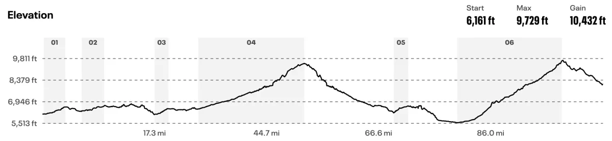
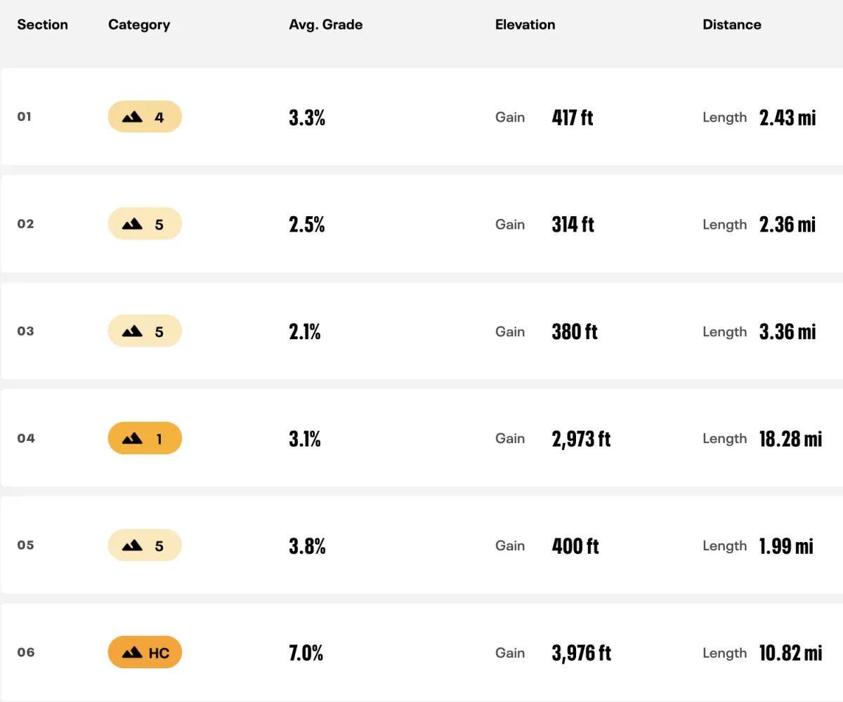
The Bike
Elevation Gain
9,246 feet / 2,873 meters
Peak Altitude
9,656 feet / 2,943 meters
Gear Requirements
Front-facing solid white headlight and rear-facing red blinking light (both mounted to the bike), bright colors or reflective vest highly recommended, flat changing kit, fully charged cell phone.
Description
The bike course will be marked at turns with signs letting the athletes and support crews know where to turn. We will have mile marking signs every 20 miles along the course.
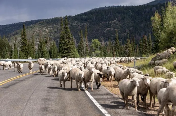
Sheep On The Course
Each year the sheep have shown up on the bike course. Please be careful on the descent from Wolf Creek Pass.
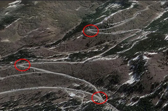
Hairpin Turns
Please be aware of the 3 hairpin turns on the downhill between miles 96 – 98. Yes you just finished climbing Guardsman Pass and all you want to do is get to T2 because it’s so close. The thing is you have to actually arrive at T2. Be a little more cautious as you travel through these 3 hairpin turns.
The Run
White Shirt Distance
Elevation Gain
3,907 feet / 1,190 meters
Peak Altitude
9,883 feet / 3,012 meters
Black Shirt Distance
Elevation Gain
3,907 feet / 1,190 meters
Elevation Gain
7,543 feet / 1,827 meters
Peak Altitude
9,883 feet / 3,012 meters
Peak Altitude
10,528 feet / 3,209 meters
Gear Requirements
When starting the run each athlete and/or support person on the run course will need to have a water bladder or bottle system, headlamp, soft shell jacket, emergency blanket, cell phone, rechargeable battery pack. Make sure to have enough nutrition to get through the first 17.5 miles. Trail shoes are recommended as the majority of the run will be on trails. Hiking poles may be used.
Description
The run course will begin at Solitude Resort. The course will be marked with color flags.
The course starts in the Solitude parking lot and heads back out to Big Cottonwood Canyon Road.The course will head down the road, left turn onto the road. Athletes will cross the road at the crosswalk at mile 3.5. This is where you will jump on the North Fork trailhead . The course will take athletes to Dog Lake.
After the lake the course follows Big Water Trail, Little Water Trail, Great Western Trail, then onto the Wasatch Crest Trail and finally onto the Wasatch Crest Connect. The course then follows the Guardsman Pass Road down to Big Cottonwood Canyon Rd. The course turns left and heads up to Brighton Ski Resort. At mile 20, the Brighton parking lot, the course splits.
At this point only participants who arrive before 8 pm and have a support runner can begin the Black shirt course. If a participant does not have a support runner they can only begin the White shirt course.
Black Shirt Finish
The course jumps on the Brighton Lakes trail. This takes athletes to the Alta Brighton Trail and then onto Summit Road. At the top of Summit Road the course turns right onto Honeycomb Canyon Trail. This trial will take athletes all the way to the finish line.
White Shirt Finish
Here athletes will continue on the road and head down Big Cottonwood Canyon Road. The course will pass the parking lot for T2 and head down 2 more miles. Here the course u-turns back up Big Cottonwood Canyon Road. The course turns into the parking lot and to the finish line.
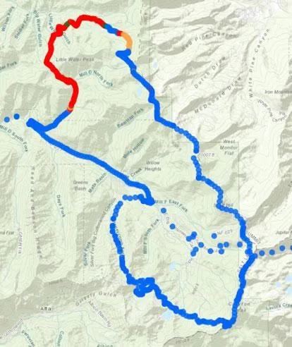
GPS Tracking
GPS tracking is provided by Adventure Enablers
The red sections on the run course identify where there is a weak signal for the GPS units. On the run course the weak signal is from mile 5 – 10. Once the athletes enter these areas the signal will become weak and we will not see updates. Once they exit these weak areas the signal will return and updates will continue.

Challenge Yourself
If you think you're tough enough...
August 2, 2025 - Only 250 race slots available
A one of a kind triathlon endurance race in one or the most challenging backdrops in America, the Utah Mountains.
Starvation XTri © 2025 | All Right Reserved | Privacy Policy | Terms & Conditions | [email protected]